D-12 Russian Unmanned Aerial Vehicle (UAV)
D-12
Tactical Unmanned Aerial Vehicle (UAV)
Other
Basic Information
Name
D-12 Russian Unmanned Aerial Vehicle (UAV)
Designation
D-12
Alternate Designation
D-12
Equipment Type
Tactical Unmanned Aerial Vehicle (UAV)
Manufacturer
Aeromax Group
Date of Introduction
2021
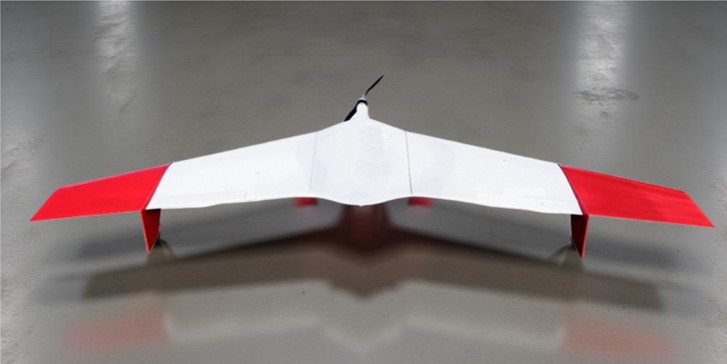
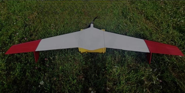
Description
The D-12 Russian Unmanned Aerial Vehicle (UAV) features a "flying wing" aerodynamic design. This model is specifically built for aerial photography and remote sensing of the Earth's surface. It is capable of carrying payloads of up to 2 kg and can cover distances of up to 250 km. Applications of the D-12 UAV include: - Aerial photography - Photo and video monitoring - Thermal imaging and multispectral photography - Aerial laser scanning
Air & Air Defense Specifications
Engine
Electric
Max Speed
126.0 km/h
Range
250.0 km
Endurance
2.50 hrs
Service Ceiling
4000 m
Wingspan
3000.00 m
Payload Capacity
2 kg
Variants
D-12K
The D-12K is a Russian Unmanned Aerial Vehicle (UAV) designed for vertical takeoff and landing, powered by an electric motor. This model has been developed to conduct various operations, including remote sensing of the Earth's surface and cargo transportation. The D-12K system comprises two main components: 1. An unmanned aerial vehicle (UAV), which is based on a "flying wing" aerodynamic design. 2. A Ground Control Station (GCS). The D-12K can be outfitted with several advanced technologies, including: - A high-resolution nadir camera - High-resolution nadir and perspective cameras - A thermal imager and a multispectral camera - A geodetic receiver that operates on L1 and L2 frequencies, in addition to a multi-system receiver - A laser scanner This sophisticated configuration enables the D-12K to accomplish its intended tasks effectively.
System
Alternate Designation
D-12
Type
Unmanned Aerial Vehicle (UAV)
Manufacturer
Aeromax Group
Payload Capacity
2 kg
Payloads Aerophotographic Camera
Aerophotographic camera is designed to capture a series of image frames of the underlying terrain from the aircraft board and saving them on a solid-state recorder
Aerial Laser Scanners
Aerial laser scanners are used for geodetic measurements during geotechnical investigations, surveying, cadastral and land management works.
Multispectral Camera
Enables images of the same area in different areas of the electromagnetic spectrum, revealing processes and phenomena that are difficult to detect in a visible spectrum image.
Professional Thermal Imaging Camera AC-130/40T
The AC-130/40T possesses a function of real-time temperature measurement and when saving photos of an object each pixel of the picture contains information about temperature.
Multipurpose Payload AC- 170/30/19T
Multipurpose payload AC-170/30/19T combines at once visual and thermal imaging matrices. This helps to reduce the camera weight and allows to receive twice as large the data during the flight, hence increasing the efficiency of air inspection.
Take-off Mode
Elastic absorbing launcher/ with launcher
Landing Mode
By parachute
Dimensions
Length
900 mm
Height
INA
Wingspan
3,000 mm
Maximum Takeoff Weight
12 kg
Automotive
Engine Name
INA
Engine Type
Electrical motor
Engine Power
INA
Maximum Speed
126 km/h
Cruising Flight Speed
80–90 km/h
Maximum Range
250 km
Service Ceiling
4,000 m
Wind limit speed, no more
15 m/s
Endurance
2.5 hours
Image Sources
Details
Country of Origin
Russia
Category
UAVs
Air > UAVs
Filter Label
D
Classification
Domain
Air & Air Defense
Equipment Status
Active
Dimensions
Length
0.9 m
Width
3 m
Height
—
Weight
12 kg
Operators (1)
Russia
Something went wrong. Please reload the page.
Reload