KWT-TMOP-300 Chinese Tethered Unmanned Aerial Vehicle (UAV)
KWT-TMOP-300
Tactical Unmanned Aerial Vehicle (UAV)

Other
Basic Information
Name
KWT-TMOP-300 Chinese Tethered Unmanned Aerial Vehicle (UAV)
Designation
KWT-TMOP-300
Alternate Designation
KWT-TMOP-300
Equipment Type
Tactical Unmanned Aerial Vehicle (UAV)
Manufacturer
Shenzhen Keweitai Enterprise Development Co.,Ltd
Date of Introduction
2020
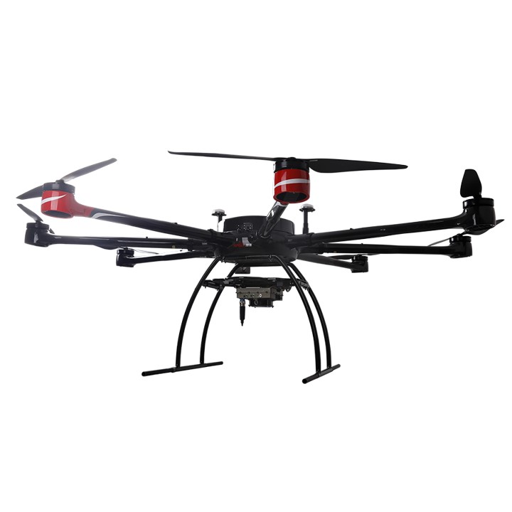
Description
The KWT-TMOP-300 Chinese Tethered Unmanned Aerial Vehicle (UAV) is used for industrial applications, aerial photography, telecom applications, inspection, instrument, monitoring, civilian, offshore applications, mapping, logistics, observation, reconnaissance, for the movie industry, for exterior security applications, for photogrammetry, gas detection, for heavy loads.
Air & Air Defense Specifications
Endurance
8.00 hrs
Wingspan
3150.00 m
Variants
KWT-TMOP-100
Is used for industrial applications, aerial photography, telecom applications, inspection, instrument, monitoring, civilian, offshore applications, mapping, logistics, observation, reconnaissance, for the movie industry, for exterior security applications, for photogrammetry, gas detection, for heavy loads.
System
Alternate Designation
KWT-TMOP-300
Type
Tethered Unmanned Aerial Vehicle (UAV)
Manufacturer
Shenzhen Keweitai Enterprise Development Co.,Ltd
Autonomy
Semi-Autonomous
Crew
Unmanned
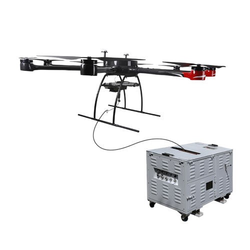
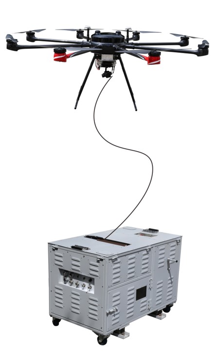
Cable Length
350 m
Maximum Working Load
25 kg
Launching System
Vertical Take-Off and Landing (VTOL)
Recovery System
Vertical Take-Off and Landing (VTOL)
Dimensions
Length
INA
Wingspan
3,150 mm
Motor Wheelbase
2,320 mm
Fuselage Height
900 mm
Weight, Empty
19 kg
Maximum Takeoff Weight
56 kg
Automotive
Engine Name
INA
Engine Type
INA
Engine Power
INA
Tethered Flight Climb Speed
2 m/s
Tethering Flight Decent Speed
1 m/s
Maximum Free Flight Speed
15 m/s
Maximum Free Flight Climb Speed
4 m/s
Maximum Free Flight Descent Speed
2 m/s
Maximum Working Altitude
5,000 m
GNSS Single-Point Hovering Accuracy
± 2m horizontally, ± 1.5m vertically
GNSS RTK Hovering Accuracy
Vertical direction: ± 0.2m
Endurance
8 hours
Image Sources
Notes
https://www.keweitai.com/kwttmop300; https://www.aeroexpo.online/es/prod/alltech/product-176104-75580.html; https://x.com/IndustrialUAV/status/1327161108692549633; https://pdf.directindustry.com/pdf/shenzhen-keweitai-enterprise-development-co-ltd/manpack-drone-system-technical-information/161742-927633.html;
Details
Country of Origin
China
Category
UAVs
Air > UAVs
Filter Label
K
Classification
Domain
Air & Air Defense
Equipment Status
Active
Dimensions
Length
—
Width
—
Height
—
Weight
56 kg
Operators (1)
China
Something went wrong. Please reload the page.
Reload